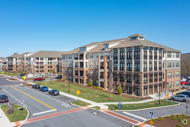
Property Record
350 Creamery Way, Exton, PA 19341

NEARBY LISTINGS FOR SALE OR LEASE
-
-
View all Exton listings for sale on LoopNet.com
Property Detail
350 Creamery Way
Philadelphia-Camden-Wilmington, PA-NJ-DE-MD
Oaklands Bus Park Ph 03
41-005-0097.0000
5 AC LOT & APT
Apartment
Chester
AE
Pennsylvania
42029C0150G
25a
2024
30.60 AC
2025
Upper Chester County
304404
Philadelphia
281,144 SF
DEMOGRAPHICS near 350 Creamery Way
1 Mile
3 Mile
5 Mile
2024 Total Population
6,685
51,758
117,208
2029 Population
7,376
54,564
123,154
Pop Growth 2024-2029
+ 10.34%
+ 5.42%
+ 5.07%
Average Age
41
40
41
2024 Total Households
2,684
19,545
44,810
HH Growth 2024-2029
+ 10.02%
+ 5.56%
+ 5.22%
Median Household Inc
$124,342
$122,443
$117,978
Avg Household Size
2.40
2.60
2.50
2024 Avg HH Vehicles
2.00
2.00
2.00
Median Home Value
$450,109
$433,745
$453,666
Median Year Built
1983
1984
1984
Nearby Places
Map Layers
Map Styles
 Street
 Aerial
- Restaurants
- Banks
- Shops
- Fitness
- Groceries
PUBLIC TRANSPORTATION
COMMUTER RAIL
Whitford (R5 - Southeastern Pennsylvania Transportation Authority Regional Rail (SEPTA Regional Rail))
DRIVE
WALK
Distance
Whitford (R5 - Southeastern Pennsylvania Transportation Authority Regional Rail (SEPTA Regional Rail))
3 min
18 min
1.0 mi
Exton (R5 - Southeastern Pennsylvania Transportation Authority Regional Rail (SEPTA Regional Rail))
DRIVE
WALK
Distance
Exton (R5 - Southeastern Pennsylvania Transportation Authority Regional Rail (SEPTA Regional Rail))
5 min
2.1 mi
AIRPORT
Philadelphia International
DRIVE
WALK
Distance
Philadelphia International
49 min
31.1 mi
Freight Ports
Port of Wilmington, RI
DRIVE
WALK
Distance
Port of Wilmington, RI
46 min
26.4 mi
Nearby Properties
Address
Land Use
TOTAL SIZE
Lot Size
Zoning
Address
Land Use
TOTAL SIZE
Lot Size
Zoning
610,762 SF
57.90 AC
OC3
Address
Land Use
TOTAL SIZE
Lot Size
Zoning
567,795 SF
4.07 AC
TCM
Address
Land Use
TOTAL SIZE
Lot Size
Zoning
434,360 SF
37.50 AC
R2
Address
Land Use
TOTAL SIZE
Lot Size
Zoning
366,578 SF
11.89 AC
TCM
Address
Land Use
TOTAL SIZE
Lot Size
Zoning
282,364 SF
34.80 AC
R1
Address
Land Use
TOTAL SIZE
Lot Size
Zoning
250,048 SF
85.08 AC
R1
Address
Land Use
TOTAL SIZE
Lot Size
Zoning
29.92 AC
I1
Address
Land Use
TOTAL SIZE
Lot Size
Zoning
387,814 SF
19.58 AC
R1
Address
Land Use
TOTAL SIZE
Lot Size
Zoning
286,082 SF
16.49 AC
R1
Address
Land Use
TOTAL SIZE
Lot Size
Zoning
477,007 SF
55 AC
I1
Address
Land Use
TOTAL SIZE
Lot Size
Zoning
212,116 SF
22.80 AC
TCM
Address
Land Use
TOTAL SIZE
Lot Size
Zoning
449,617 SF
36.60 AC
R2
Address
Land Use
TOTAL SIZE
Lot Size
Zoning
347,895 SF
11.28 AC
OC3
Address
Land Use
TOTAL SIZE
Lot Size
Zoning
267,843 SF
18.35 AC
R1
Address
Land Use
TOTAL SIZE
Lot Size
Zoning
355,649 SF
46.40 AC
R1
Address
Land Use
TOTAL SIZE
Lot Size
Zoning
272,675 SF
28.80 AC
TCM
Address
Land Use
TOTAL SIZE
Lot Size
Zoning
249,644 SF
22.58 AC
R1
Address
Land Use
TOTAL SIZE
Lot Size
Zoning
326,858 SF
45.25 AC
R2
Address
Land Use
TOTAL SIZE
Lot Size
Zoning
136,114 SF
12.20 AC
R1
Address
Land Use
TOTAL SIZE
Lot Size
Zoning
269,696 SF
21.90 AC
TCM
Address
Land Use
TOTAL SIZE
Lot Size
Zoning
140,834 SF
11.91 AC
TCM
Address
Land Use
TOTAL SIZE
Lot Size
Zoning
156,625 SF
2.89 AC
TCM
Address
Land Use
TOTAL SIZE
Lot Size
Zoning
350,085 SF
49.06 AC
OC1
Address
Land Use
TOTAL SIZE
Lot Size
Zoning
163,800 SF
21.94 AC
I2
Address
Land Use
TOTAL SIZE
Lot Size
Zoning
131,245 SF
10.10 AC
R3
Address
Land Use
TOTAL SIZE
Lot Size
Zoning
169,124 SF
8.73 AC
I1
Address
Land Use
TOTAL SIZE
Lot Size
Zoning
239,184 SF
15.50 AC
R2
Address
Land Use
TOTAL SIZE
Lot Size
Zoning
68,563 SF
33.70 AC
I1
Address
Land Use
TOTAL SIZE
Lot Size
Zoning
8.67 AC
RA
The World's #1 Commercial Real Estate Marketplace
Connect with us
© 2026 CoStar Group
The information above has been obtained from sources believed reliable. While we do not doubt its accuracy we have not verified it and make no guarantee, warranty or representation about it. It is your responsibility to independently confirm its accuracy and completeness. Any projections, opinions, assumptions, or estimates used are for example only and do not represent the current or future performance of the property. The value of this transaction to you depends on tax and other factors which should be evaluated by your tax, financial, and legal advisors. You and your advisors should conduct a careful, independent investigation of the property to determine to your satisfaction the suitability of the property for your needs.